
The plan for Day 2 was to finish what Day 1 started - get to Chame. Since it wasn't a full day of walking (only 3-4 hours), we could afford to go easy on our first day of just trekking. We had ordered breakfast the night before and set a time. By the time we showed up for our scheduled 7am breakfast, the lady had it all ready for us. We also discovered that it was as bright outside as midday. For the first time, we saw the mountains surrounding Temang in every direction. It was lovely. Many teahouses, including ours, had tables set up outside for guests to enjoy their food along with the view. We could only imagine how much better the views were going to get, if this was just the beginning.

Table at our teahouse in Temang, Nepal
After breakfast, it took us longer to get ready than expected. It was our first morning on the trek in a teahouse, and we had many new routines to get used to. Sleeping bags to roll up, a new set of belongings to remember where they were packed. We later learned that it was too hot to trek with down jackets on, and it was easier to pack it up before we left than stopping on the trail to cram puffy jackets in our bags.

Panorama of the mountains in Temang, Nepal
The initial trail onwards from Temang was not too hilly, not too sunny, and overall a great introduction to trekking. Everyone passed by us - we’re slow trekkers (more like I’m a slow trekker), but it didn't matter, because it's all about doing it at your own pace.

View of the path in the Annapurna Circuit, Nepal
We often met up with those who passed by us in later villages, so we were never too far behind. Since we were not in a rush today, we walked through the town of Thonchauk, which our book told us was a more scenic route through the village than the main road. A traditional Tibetan village, we saw stupas, farmlands, goats, all surrounded by rolling hills. We always treasure moments where we get glimpses into local life wherever we go. It's a privilege for travelers.

Temples along the way to Chame, Nepal
The route within the village dropped way down, then climbed way up to join the main road. During the way down, one section was a narrow path in a small landslide area. It wasn't dangerous or anything, but we did cross at the same time as a herd of cows came from the other side. Carlos made it across before the cows came, but of course the cows didn't know to wait until I had made it across as well. So I tried to squeeze to the side as much as I could (the side with the mountain, never the other) and thought I was pretty successful as the first cow began to pass through. The path was not big enough for both of us, so before the first cow completely passed, its large behind shoved me to the side. I don't think it purposefully did so, and it's questionable how much it even felt the small barrier that I presented. Either way, I thought it was pretty funny even though I was caught by surprise. I've never been pushed to the side by a cow before! That's why I was grinning in this photo.

Julie being pushed by a cow, Nepal
When the trail climbed up to join the road, it climbed way up. After our first suspension bridge (pretty sturdy steel and cement ones that shake only slightly), the slope looked steep. In the direct sun, we needed a few water breaks to make it up. From that point onward, we were soon out of the village and back onto the main road.
Our first viewpoint moment came soon after. Along a stretch of road on the side of a valley, we looked back to see the village we had just walked through with its many colorful houses and green rice paddies, framed by snow-capped mountains in the background. In the closer foreground, a blue-grey river ran through the valley. With a clear blue sky, the scenery was perfect. Our camera couldn't capture it all, but it had the photo composition formula to a tee.

View of Thanchok, Annapurna Circuit, Nepal
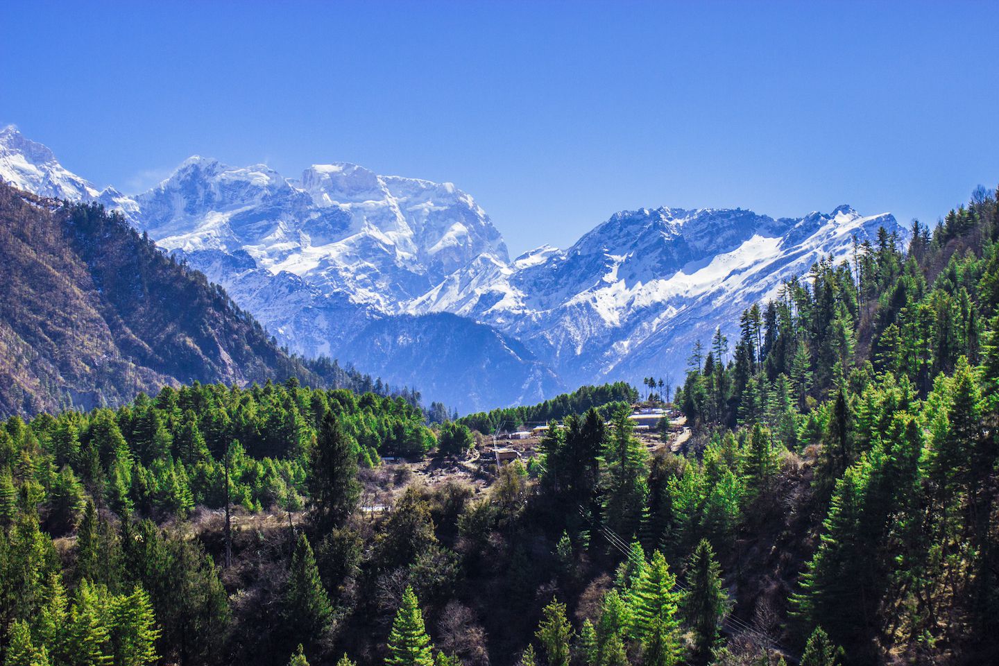
That first viewpoint really added a spring to our steps. Along the rest of the way, I don't remember feeling the fatigue or even minding the occasional mud on the road. There was always glimpses of majestic snowy peaks to look forward to.

Partial view of the Annapurna Himalayan Range, Nepal
Before we started the trek, I found it hard to know what to expect, because there's nothing quite equivalent to trekking the Himalayas. I read other people's blogs but there was still a lot of uncertainty and doubt. It's hard to imagine what it would be like to wear a backpack and walk all day if you haven't done it before, or what sleeping in teahouses in the mountains will really feel like. Today we were finally living it for real, and all of my questions were being answered. It was a relief to know that we found everything manageable and pleasant.

Carlos trekking from Temang to Chame, Nepal
All this happiness ended abruptly at the ACAP checkpoint in Koto, not far from Chame, our final destination for the day. While the police checked our ACAP permits, we casually chatted with them. Usually when Carlos says he's from Brazil, a lot of people respond with football (it really is the world's sport). The policemen in Koto were particularly knowledgeable about football and we discussed World Cups and UEFA Championships past and future. I think it was because we had struck up a conversation that the police eventually asked where we were headed and told us the bad news:
Thorong La Pass was closed.
Not just Thorong La Pass, but even the route to Manang was closed, and (Upper/Lower) Pisang may or may not be reachable. I don't think what he said really registered in our heads the first time. We kept asking him to repeat it because how could those places be closed? Apparently there had been a snowstorm a few days ago and there was too much snow in the higher altitude areas that it was not accessible.

Julie arriving in Koto, Nepal
This was the first time we had ever heard news of this sort. Everyone in Kathmandu raved about the weather, that since the initial rain when we first arrived a week ago, the weather would be wonderful for the next 15-20 days. We had trekking companies quote us itineraries through Thorong La Pass. We obtained permits to trek the Annapurna Circuit from the National Tourism Board who knew the days we planned to be on the trail. For goodness sake, we checked in at 1) a TIMS checkpoint in Besisahar on Day 0 and 2) an ACAP checkpoint in Dharapani on Day 1. NOBODY SAID ANYTHING!
We had thought of all kinds of crazy (mostly bad) scenarios that could happen during the trek, but it never, ever occurred to us that part of the trail could be closed. We were stunned. All the energy drained out of our bodies and minds. We felt like fools for not knowing until now. Did we just not find out in Kathmandu? How can the pass be closed? Is it really true? It must be true, why would the police lie about this? Why haven't we heard this from anyone else until now?

Julie crossing a suspension bridge on the way to Chame, Nepal
That last half hour walk to Chame was nothing like the earlier three hours. Our minds searched frantically for answers. It also connected the dots. Yesterday on the jeep ride up, we saw an abnormal number of people heading down the same path, both walking and in jeeps. Since the Annapurna Circuit trail goes down the other side, we didn't expect to see anyone heading down this way (except the very few who choose to do the circuit backwards). We had pondered briefly, but were too preoccupied with fearing for our lives. I figured they had problems acclimatizing and had to come down or something like that. Obviously there were way too many (healthy-looking) people coming down for them to all have altitude sickness, but I had no other explanation for it and I figured I would find out later. Now I knew why.
When we arrived in Chame, other trekkers confirmed the news. They had heard as well, mostly from other trekkers on their way down. Since this was our first day trekking, we didn't have any other opportunities to meet other trekkers before now. Even if we had, I can't say I would have for sure asked because the thought never once crossed our minds. At least we found out that no trekkers coming from Kathmandu knew (apparently no authorities responsible bothered to make a 1-min phone call and relay the news) so there's nothing we could have done. Trekkers coming from Pokhara knew (most likely because trekkers coming down from both the west and east side already reached there and spread the news). What does it say about the ACAP organization, the TIMS, the government in general if it takes foreigner trekkers to spread the news about one of the most popular trekking routes in the entire country being closed?? Like I said, I had a feeling the cards and permits were useless - what's the point of registering as a trekker with a detailed itinerary (so they can trace yours steps in case something bad happens) if they can't even notify me of the conditions of the route I'm registered to trek??

View from our room in Chame, Nepal
The rumors began that afternoon in Chame and continued for the rest of our trekking days. People said the pass could open tomorrow or it could open in a month. There was talk of avalanches, talk of meters and meters of snow covering the trails. One local froze to death in Manang because it was so cold, prompting other locals to come down to lower altitudes and warmer villages. A few people died on their way crossing Thorong La down to Muktinath. We didn't know for sure what was true and what wasn't, but all the stories were terrifying. There were more rumors going around than in high school time.
We paid the ACAP office in Chame a visit, hoping for some definitive facts amidst all the rumors. As expected, the guy gave a diplomatic answer. He neither discouraged us from going further, nor guaranteed us the pass would open. All he could say for sure was that eight people had checked into the ACAP checkpoint in Manang and that a hotel entrepreneur in Manang said they would send some locals and yaks (yes, they use yaks to clear the snow) to start clearing the trail soon. It was concerning that he had to get news from a hotel entrepreneur and not the ACAP office in Manang, which must mean the offices don't know anything. That guy also knew less than we did about the whole situation from just talking to other trekkers, so clearly the ACAP offices couldn't be depended on for anything.

Sunset in Chame, Nepal
All everyone talked about for the rest of the day was this. Many (mostly trekkers with guides) had already decided to head down, while others (mostly independent trekkers) were determined to keep going and wait for the trail to be open again. We were somewhere in between. There was no immediate rush to go down (especially since this was our first day of actual trekking!), but we were not equipped to handle a lot of snow. We are amateur trekkers already taking enough risks with the trail in perfect conditions. All of those worries about altitude sickness or knee pain? Completely out the window now that the priority was to not die.
We agreed to try to go as far as we could and assess the situation as we go. If at any point we felt like it was too dangerous to go on, we would turn around and head back. It was far from ideal, but the best we could manage under the circumstances. We went to bed not knowing at all what to expect tomorrow. Day 2 was a total 180 - started off incredibly well and ended in total confusion and uncertainty.
Continue to read Trekking Annapurna Day 3: Crossing Avalanches…
For more pictures from Temang and Chame, please visit the gallery!